The Hunting & Fishing Magazine of the Dakotas!
SUBSCRIPTION LOG IN
Each month, from January through the end of the runoff season, Missouri River water managers and weather forecasters report the conditions of the Missouri River Basin.
Missouri River Water Management Monthly Update - Each month, from January through the end of the runoff season, Missouri River water managers and weather forecasters report the conditions of the Missouri River Basin.
Missouri River Water Management Weekly Update - May 8, 2018
System storage is currently 60.9 MAF, 4.8 MAF above the base of the Annual Flood Control and Multiple Use Zone. Approximately 70 percent of the 16.3 MAF of designated flood control storage remains available to capture runoff from rainfall runoff and mountain snowmelt. As shown in the System Storage Comparison to the right, there is approximately 4.7 MAF more storage available this year than at the same time in 2011. The service level is currently 50,000 cfs(15,000 cfsabove full service); no change from the mid-April adjustment.
Missouri River Mainstem projects will maintain higher than average releases
Posted 5/8/2018
OMAHA, NE – The U.S. Army Corps of Engineers (Corps) Missouri River Basin Water Management Division plans to maintain higher-than-average releases from all System projects, including Gavins Point, over the next several months. “Due to higher-than-average runoff being forecast in the Missouri River Basin above Sioux City, Iowa, we have increased the service level 15,000 cubic feet per second (cfs) above full service to facilitate the evacuation of stored flood waters. The increased service level means that Gavins Point releases may be increased to 42,000 cfs, and possibly higher, as downstream tributary flows recede,” said John Remus, Chief of the Missouri River Basin Water Management Division. Gavins Point releases will be adjusted, when needed, in response to basin conditions. When necessary, the Corps will reduce releases from the System projects and utilize the available flood control space in the reservoirs, in order to lessen flooding downstream of all the projects. It is important to note that the ability to significantly reduce flood risk along the lower Missouri River diminishes at locations further downstream due to the large uncontrolled drainage area and the travel time from Gavins Point Dam.
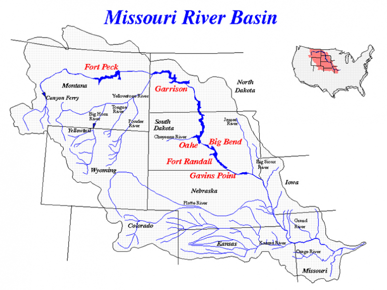
The 2018 runoff forecast in the Missouri River Basin above Sioux City, Iowa, is 33.2 million acre feet (MAF), 131 percent of average according to the Corps. “The updated runoff forecast increased 3.0 MAF from April’s forecast. This was due to the continued accumulation of mountain snowpack in the upper basin as well as the delayed melt of plains snow during the first two weeks of April,” said Remus. “Based on the current mountain snowpack and temperature and precipitation outlooks, runoff into the Fort Peck and Garrison reservoirs is expected to be above average from May through August,” said Remus.
As of May 1, the mountain snowpack was 135 percent of average in the reach above Fort Peck and 129 percent of average in the reach from Fort Peck to Garrison. It appears that the mountain snowpack has peaked in both reaches: on April 19 in the Fort Peck reach and on April 15 in the Fort Peck to Garrison reach. View the mountain snowpack graphic here: http://www.nwd-mr.usace.army.mil/rcc/reports/snow.pdf.
The Missouri River mainstem reservoir system (System) storage was 60.6 MAF as of May 1, occupying 4.5 MAF of the 16.3 MAF flood control zone. “More than 70 percent of the System’s flood storage remains available to capture runoff from the mountain snowmelt and spring and summer rainfall events,” said Remus.”
Weekly updates on basin conditions, reservoir levels and other topics of interest can be viewed here: http://www.nwd-mr.usace.army.mil/rcc/reports/pdfs/weeklyupdate.pdf.
The Corps will continue to monitor basin and river conditions, including rainfall and mountain snowmelt, and will adjust the regulation of the System based on the most up-to-date information.
Reservoir Forecasts
Gavins Point Dam releases averaged 34,000 cfs during April. Releases were increased to 36,000 cfs during early April, but were reduced near the end of the month due to higher flows downstream. Releases were increased to 37,000 cfs in early May. Downstream conditions permitting, releases will gradually be increased until they reach the expanded navigation support levels, which are estimated at 40,000 to 42,000 cfs. The Gavins Point reservoir ended April at elevation 1207.1 feet and will remain near 1206.0 feet during May.
Fort Randall Dam releases averaged 30,000 cfs in April. Releases will be adjusted as necessary to maintain the desired reservoir elevation at Gavins Point. Due to on-going maintenance at the project, planned releases will require releases from the powerhouse and outlet tunnels. The reservoir ended April at elevation 1358.1 feet, rising 1.4 feet during the month. The reservoir will gradually fall to near 1355.2 feet during May.
Big Bend Dam releases averaged 25,900 cfs in April. Releases are expected to average 28,000 cfs during May. The reservoir will remain near its normal elevation of 1420.0 feet during May.
Oahe Dam releases averaged 27,900 cfs during April. Releases are expected to average 27,500 cfs in May. Planned releases will primarily be through the powerhouse, however, outlet tunnels may be used this spring during powerhouse maintenance. The reservoir ended April at elevation 1610.1 feet, rising 1.2 feet during the month. The reservoir level is expected to rise 2.2 feet during May.
Garrison Dam releases averaged 28,100 cfs during April. Releases were increased to 37,000 cfs in early May. Garrison reservoir ended April at elevation 1842.4 feet, rising 3.4 feet during the month. The reservoir level is expected to rise 1.0 foot during May, ending the month near elevation 1843.4 feet.
Fort Peck Dam releases averaged 9,400 cfs during April. Releases were increased to 11,000 cfs on April 22 and will increase to 14,000 cfs around mid-May. The planned release is near the maximum powerhouse release, however due to ongoing maintenance at the project, releases will be required from both the powerhouse and spillway. The reservoir ended April at elevation 2239.9 feet, rising 3.9 feet during the month. The reservoir is expected to rise 1.9 feet during May ending the month near elevation 2241.8 feet.
The forecast reservoir releases and elevations discussed above are not definitive. Additional precipitation, lack of precipitation or other circumstances could cause adjustments to the reservoir release rates. To view the detailed three-week release forecast for the mainstem dams, go to http://www.nwd-mr.usace.army.mil/rcc/reports/twregfcast.pdf. •


BISMARCK, NORTH DAKOTA — Nate Stumpf, chairman of the Agassiz 4-Curls...MORE

The South Dakota Game, Fish and Parks Commission recently adopted a...MORE

Years ago, I hardly knew anyone who went afield specifically in...MORE
The North Dakota Game and Fish Department, local...MORE