The Hunting & Fishing Magazine of the Dakotas!
SUBSCRIPTION LOG IN
OMAHA, Neb. -- Drought conditions continue to impact the upper Missouri River Basin above Sioux City, Iowa (upper Basin). July runoff in the upper Basin was 34% of average. July runoff above Fort Peck Dam was the lowest in 123 years of record-keeping.
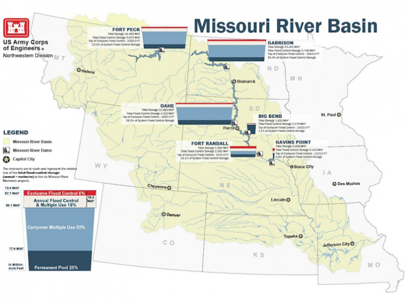
The updated 2021 upper Basin runoff forecast is 14.6 million acre-feet (MAF), 57% of average. If realized, this runoff amount would be the 10th driest year in the upper Basin since 1898. System storage on August 1 was 53.9 MAF, 2.2 MAF below the base of the Annual Flood Control and Multiple Use Zone. System storage is expected to decline further into the Carryover Multiple Use Zone during the remainder of 2021.
“Reservoir inflows in July have been declining due to the warmer and drier conditions in the upper Basin,” said John Remus, chief of the U.S. Army Corps of Engineers’ Missouri River Basin Water Management Division. “Per the July 1 System storage check, navigation support will be maintained at an intermediate service level, 1,500 cubic feet per second (cfs) below full-service levels, through the end of the normal 8-month navigation flow support season, which will end on Dec. 1 at the mouth,” added Remus.
USACE will evaluate lower Missouri River flow conditions to set Gavins Point releases to ensure that flows at the four downstream navigation target locations will be at or above the intermediate service level. The monthly study also indicates that the winter release from Gavins Point, which is based on the September 1 System storage check, will likely be at a minimum rate of 12,000 cfs.
Fall public meetings are currently scheduled to be held October 25-28 at several locations along the Missouri River. Locations and details will be included in the September update.
Drought Conditions:
Soil conditions in the upper basin are very dry. Drought conditions throughout the entire Basin, particularly in the upper basin, worsened in July. According to the National Drought Mitigation Center, approximately 75% of the Missouri River basin is currently experiencing some form of abnormally dry or drought conditions, an increase of 10% since the end of June. The seasonal drought outlook, which extends through the end of September, shows drought conditions will persist or expand across the upper basin. Drought information can be viewed at: https://droughtmonitor.unl.edu/.
Navigation:
Gavins Point Dam releases will be set to provide flow support at an intermediate service level, 1,500 cfs less than full service flow support at all four target locations (Sioux City, Omaha, Nebraska City, and Kansas City). Flow support for the second half of the navigation season, as well as the navigation season length, are based on July 1 System storage. The flow support season length will be a full 8-month season, ending Dec. 1 at the mouth of the Missouri River.
Mountain Snowpack:
Mountain snowpack in the upper Basin melted out in mid- to late-June, several weeks earlier than normal. The mountain snowpack peaked above Fort Peck in late March at 86% of average, while the mountain snowpack in the Fort Peck to Garrison reach peaked in late April at 96% of average. Mountain snowpack normally peaks near April 15. The mountain snowpack graphics can be viewed at: http://go.usa.gov/xARQC.
Winter Release Rate:
The winter release rate is determined based on the September 1 System storage. Per the July 1 reservoir studies, the winter releases from Gavins Point Dam will likely be at the minimum rate of 12,000 cfs.
Monthly Water Management Conference Calls
Water management calls include an update from the National Weather Service’s Missouri Basin River Forecast Center, and an update on the Missouri River mainstem reservoir system operations. The next call for 2021 will be held on Thursday, August 5. All calls are recorded in their entirety and are available to the public on our website at https://go.usa.gov/xARQv.
Reservoir Forecasts:
The forecast reservoir releases and elevations discussed above are not definitive. Additional precipitation, lack of precipitation or other circumstances could cause adjustments to the reservoir release rates.


Each month, from January through the end of the runoff season,...MORE
The North Dakota Game and Fish Department tracked 40 outdoors-related...MORE


Devils Lake, ND: “Social Distancing” to Devils Lake fishing guides is...MORE
This is the magical time of year at Devils Lake, North...MORE